Hexham - Bardon Mill - Vindolanda - Hadrian's Wall - Haltwhistle
HADRIAN'S WALL
Over the Easter holidays, I took my two children (12 & 9) to visit Hadrian's Wall, in the Northumberland National Park.
I have always been fascinated by Roman history, and its legacy that remains throughout Britain. That legacy is either cultural, such as language, foods, law and order, distances (miles), currency etc; or physical remains such as roads, buildings and walls. The very best place to see Roman remains in Britain is undoubtedly Hadrian's Wall, a militarised zone that stretched 80 Roman miles from Bowness-on-Solway to Wallsend. According to Roman records, this wall was built to separate the Romans from the Barbarians to the north of the wall! It was really more of a 'customs border' to control movement into the Roman Empire.

Built on the orders of Emperor Hadrian in AD122, Hadrian's Wall was 15 Roman feet high and 10 feet wide, and was a major feat of Roman engineering, with gated Milecastles every (you guessed it) mile, with two turrets in between and then a series of major forts every 7 or so miles. A deep and wide ditch, known as the Vallum, was built to the south of the wall, then just south of this huge ditch was the Stanegate, a Roman military road that pre-dates the wall by around 25 years.
Hadrian's Wall was in use for 300 years until around AD406. The forts were garrisoned with soldiers from across Europe and North Africa. Small towns developed around the forts. Roman soldiers married local people. Families were built over the centuries. When the Roman Empire began to crumble, the people of Hadrian's Wall remained; their descendants are still there today.

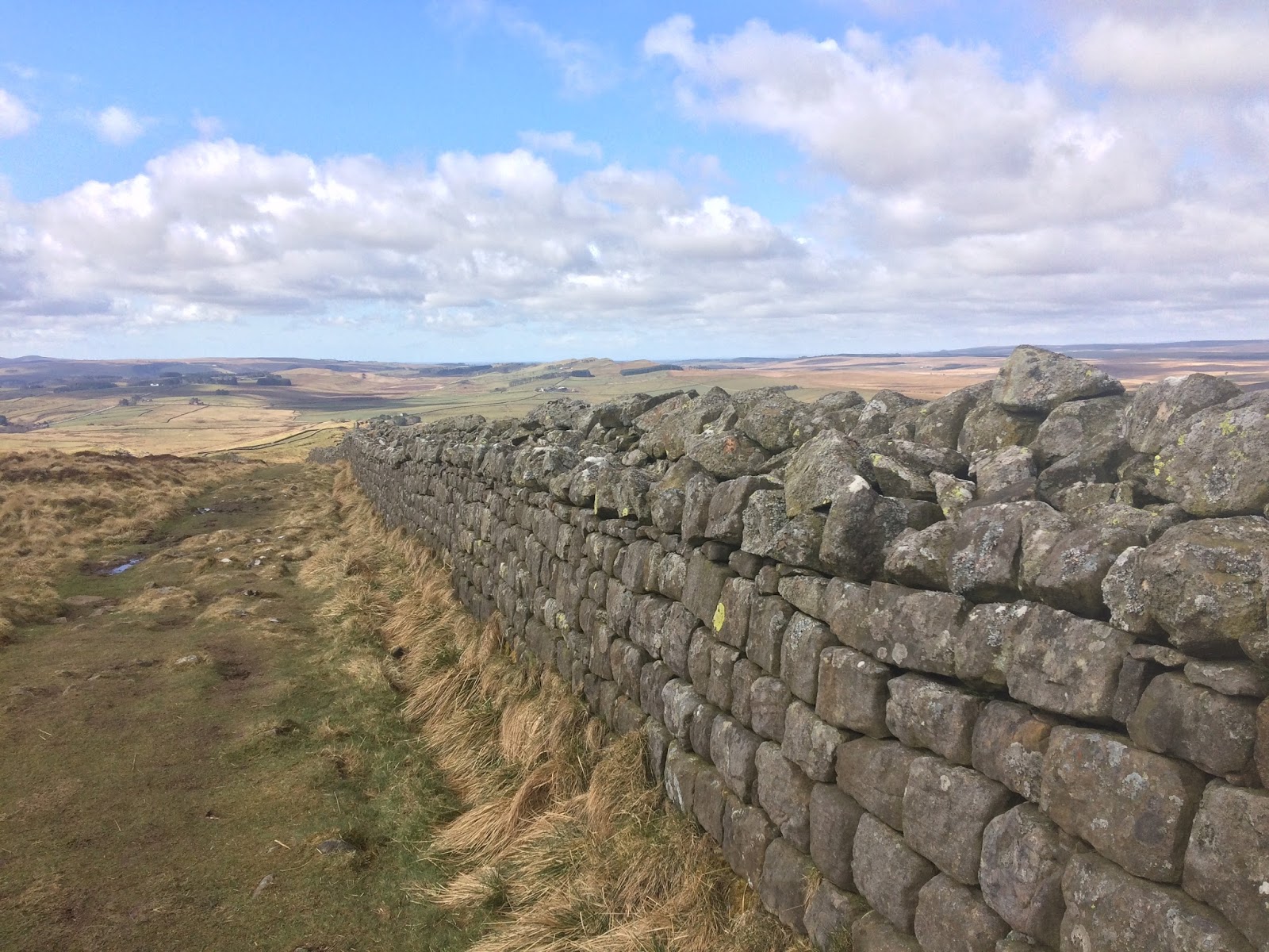
Some of the best preserved sections of Hadrian's Wall are along Peel Crags (with the famous 'Sycamore Gap'), Winshield Crags and Cawfield Crags, where the wall (still several feet high in places) traces the crest of the famous Whin Sill crags. This stretch can be found just to the north of Bardon Mill and Haltwhistle. The sense of history and place are tangible as you walk alongside the wall, rising and falling like a huge wave across the landscape. The neat small stone blocks, the skill of the masons, the rugged inhospitable terrain. What must it have been like to be stationed on this wall, looking northwards for advancing Picts?
VINDOLANDA
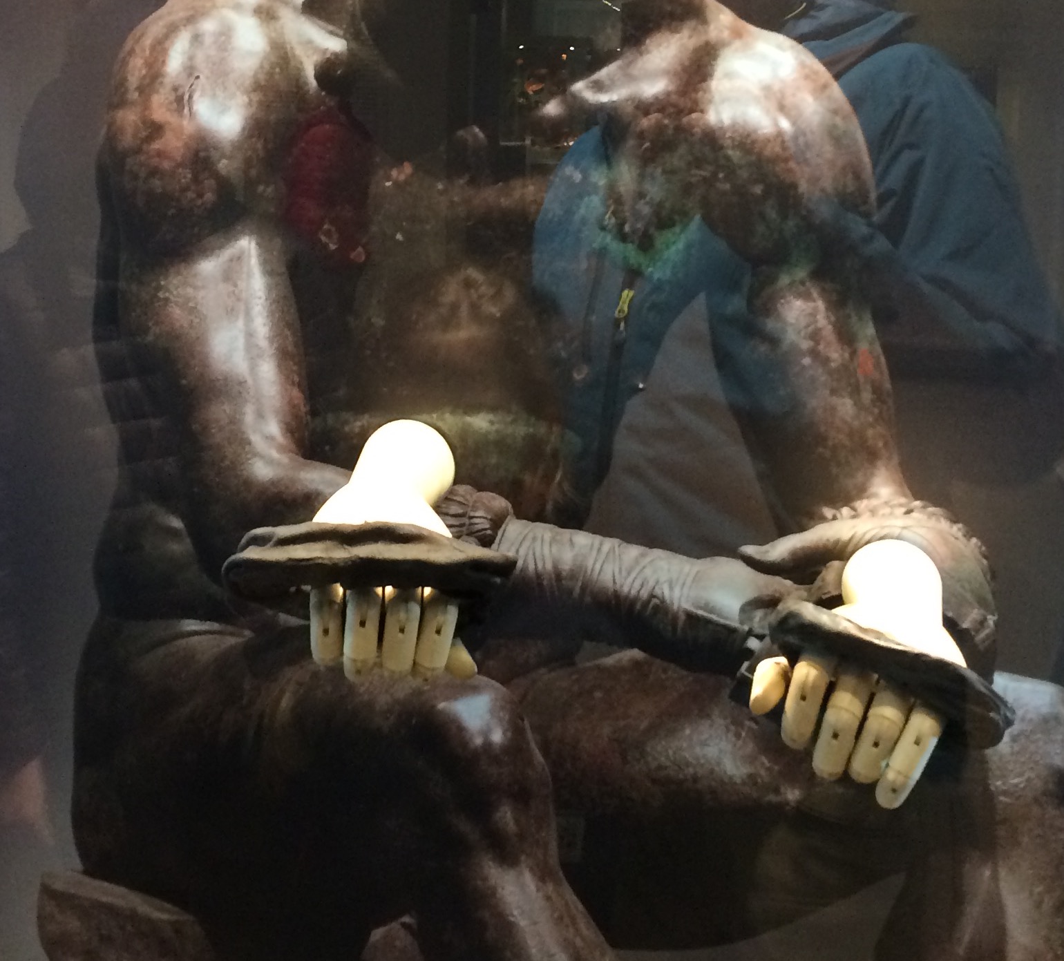
To get a sense of what it was like living along the wall, then a visit to the Roman Fort of Vindolanda is a must. Here you will find a well-preserved fort along the Stanegate, with paved streets, an assortment of buildings and temples, bathhouses, and a reconstructed section of the wall. However, the most amazing thing about Vindolanda are the huge array of archaeological treasures discovered in the water-logged soil, many of which are amazingly well preserved, including the famous Vindolanda Tablets fragments of letters written on thin strips of wood that document the everyday lives of Romans living at the fort.

Some of the artefacts that caught my eye were...
A huge variety of Roman shoes

A well preserved Horse Chamfron

A wig made out of moss to keep the midges at bay

some rather rude carvings to denote strength and good fortune against the Picts.

And the famous Roman boxing gloves
To get the most from our day, we used Northern Hadrian's Wall Country Line Day Ranger to move between Hexham, Bardon Mill and Haltwhistle Stations.

Hexham is a wonderful town to explore, with its Abbey founded in the 7th Century by St Wilfred and England's first purpose-built goal that dates back to 1330.
After exploring the town, we then caught the Northern train to Bardon Mill from where we walked up to Hadrian's Wall via Vindolanda, then westwards along Hadrian's Wall before dropping down to Haltwhistle where we caught the Northern train again.
There is also the 'AD122' bus service that serves the key locations along Hadrian's Wall between Hexham and Haltwhistle (including Vindolanda), so you can extend or cut short your walk as you choose.

OUR WALK
OS Map: Explorer OL43 'Hadrian's Wall'
Distance: About 9 miles in total
Time: All day, with visits to Vindolanda, Hadrian's Wall and The Sill
Refreshments: Vindolanda (cafe), Twice Brewed Inn and The Sill (Information Centre, Youth Hostel and cafe), Milecastle Inn (Grid Ref: NY 716 660), Haltwhistle (plenty of choice)
Route:
From BARDON MILL we followed minor country lanes north-westwards passing Westwood Cottages then along Park Lane before heading northwards along the byway (NY 764 655) passing Kingcairn Hill to reach VINDOLANDA (at least 2 hours required to explore properly).
From Vindolanda, we walked north-west to The Sill and Twice Brewed, then northwards to reach Hadrian's Wall at ONCE BREWED. We then followed Hadrian's Wall westwards over Winshield Crags and Cawfield Crags then, at Milecastle 42, headed south to the MILECASTLE INN then followed the path southwards via Haltwhistle Burn into Haltwhistle.
With such great public transport links, then you can devise your own walk to suit.
You may also wish to visit...
Corbridge Roman Town
Chesters Roman Fort and Roman Bridge across the River North Tyne
Housesteads Fort
Roman Army Museum and Thirlwall Castle
Sycamore Gap (NY 762 677)
PLACES TO STAY
We stayed at the new Youth Hostel at The Sill, which is ideally located just south of Hadrian's Wall near Vindolanda.
With thanks...
Vindolanda Roman Fort entry tickets provided by Vindolanda
Rail Travel provided by Northern

No comments:
Post a Comment